de / en

HINT

Get our picnic backbag for your hikes and enjoy the breathtaking beauty of nature 

Hike in Hike out

HIKINGTRAILS

There are several hiking trails from the hotel and in the area for professionals and families alike. Here is just one example.
You can get a hiking map of the Zillertal Arena at our reception.


  • HIKE TO THE MOUNTAIN RESTAURANT GIPFELTREFFEN
    Easy: Take the village railway to the Gipfeltreffen mountain restaurant and hike down
    Medium: Approx. 02:00 h | Yodelling hike: Along the yodelling trail to the Larmachalm and from there to the Gipfeltreffen mountain restaurant. Most beautiful view of the Hohe Tauern National Park and the Zillertal Alps, to Königsleiten.
    Difficult: approx. 4.5 h | Through the Salzach Valley and through the Müllach Valley via the Müllachgeier to the Gipfeltreffen mountain restaurant
  • HIKE KÖNIGSLEITEN - MÜLLACHTAL - SALZACHTAL
    approx. 03:00 h | trail no. 62 / 63
    Take the Königsleiten lift up to the mountain station - from there you start to the Müllachgeier, then continue via the Mottland-Grundalm into the Salzach Valley.

hike in hike out

WANDERLUST & pleasure

HIKE PLATTENKOGEL - SCHÖNMOOS ALM 
7.62 km // 399 m // approx. 3:00 h

Start from here through the village to Direkt Holidays | Verkehrsverein, then through the mountain forest on hiking trail no. 50 to Gerlosplatte | Silberleiten | Plattenkogel. Past the Plattenalm
past lush alpine meadows to the Gletscherblickalm viewpoint.

HINT: short ascent to the summit of the Plattenkogel with breathtaking views of the surrounding 3000 metre peaks and the Zillertal and Kitzbühel Alps. Back and on to the
Breitscharte, from there on hiking trail no. 49 towards Krimml to the Schönmoosalm.

Duration approx. 3 hours | medium-difficulty hike

Or start in Hochkrimml to Filzstein - from here the trail leads across alpine meadows to the summit cross of Krimml's local mountain - the Plattenkogel. Trail no. 49 bend 7
Return journey possible with our own shuttle bus - mybergliebetaxi.at

Info & opening hours: 

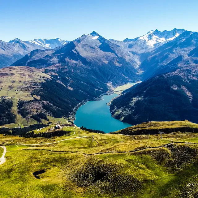
Atemberaubende Aussicht

RUNDWANDERUNG DURLASSBODEN STAUSEE

Start beim Parkplatz der Sonnwendkopfbahn (mit dem Auto ca. 5 Min) – gerne kann man aber auch von hier aus starten
(Gehzeit ca. 30. Min bis zum Parkplatz der Sonnwendkopfbahn)

Von hier aus geht man durch das Dorf bis zum Direkt Holidays | Verkehrsverein und biegt dann links ab. Der Straße
folgt man bis zum Ende und biegt dann rechts ab solange bis wieder Links eine Abzweigung folgt. Diesen Weg folgt man dann bis zum Parkplatz der Sonnwendkopfpahn. 

Weiter geht’s zur Bräueralm, von hier aus startet man nun die Wanderung welche einmal rund um den See führt. Hier geht man rechts Richtung Seestüberl - über die Staumauer – Bärschlagalm und wieder Retour zum Ausgangspunkt. An heißen Tagen kann man sich an den verschiedenen Badeplätzen eine Abkühlung holen.
 

Dauer: ca. 3h 30 Min (vom Parkplatz aus)
Mittelschwere Wanderung

GALAXY

PLANETARY PATHWAY

The 6 km long planetary hiking trail around Königsleiten is intended to make the dimensions of our solar system comprehensible for human understanding. The basis for this trail is a model scale, where 1 metre on the hiking trail corresponds to a distance of 1 million km in the solar system.

From here, turn right to the Hotel Sterngucker, from there follow the road towards the entrance to the village and after the tourist office turn left into the forest, after 150 metres follow the fork to the right and continue following the markings (yellow/blue) to the Strasseralm. Before the mountain pasture, turn left up to the Planetenstein. The way back leads past the lift station to the hotel.

The planetary positions are marked by large stones. These blend into the landscape like Celtic monoliths. Each of these stones provides information about the proportions in the solar system. The segment of the golden circle shows the circumference of the sun (on the scale above). Just above it, on the left-hand side, you will find a small blue sphere: the Earth. The relative size of the individual planets is indicated under their names. The panels next to the planets provide information about the most important parameters of each planet. Note, for example, how close the planets Mercury and Mars are to each other, but how infinitely far apart the outer planets Jupiter and Pluto are!

Duration: approx. 2h 30 min
Moderately difficult hike

Water experience

WATERFALL HIKING TRAIL

The lowest waterfall is a 10-15 minute walk from the car park. From there, the serpentine waterfall trail leads to the uppermost waterfall (walking time approx. 1.15 hours) and on into the Krimml Achental valley. Viewing platforms provide spectacular views of the thundering water masses of the Krimml Waterfalls.

Subject to a fee
Mid-April to the end of October. | Open all day

YODELLING & HIKING

Guided yodelling hike

An easy hike in the middle of the week with Christian and a short yodelling course. Ascent with the cable car. Once at the summit, there's a Juchizza to warm up your voice and then off you go. You will learn simple yodelling songs at the individual stations. The hike will be a pleasure for all the senses and will end with the awarding of the yodelling diploma.

Dates: Wed 16.07.2025 | Wed 30.07.2025 | Wed 13.08.2025 | Wed 27.08.2025 | Wed 03.09.2025| Wed 10.09.2025

Wandern Kreuzjoch Sonnenaufgang | © Zillertal Arena

FOR EXPERIENCED HIKERS

HIKE TO THE MARKKIRCHL

Our recommendation for experienced hikers is the fantastic tour to Markkirchl: starting from Salzachtal (approx. 10 min. by car, located on the old Gerlospass road), you can park at the signposted "Salzachhütte" car park. From there it's a 1.5-hour walk to the Tyrolean border in the direction of Markkirchl / Nadernachjoch, where you will also come across the source of the Salzach. (Hiking trail no. 734, then 718). Enjoy marvellous viewpoints & fresh mountain energy.

My Alpenwelt

Bergliebe Radio

x

Radio im neuen Fenster öffnen